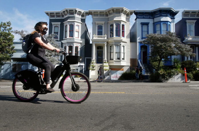
Every weekend along Marina Green, I see tourists walking or riding rental bicycles as they head to cross the Golden Gate Bridge. Recently, however, I’ve seen more of them riding in the Presidio, on Slow Lake Street, on JFK Promenade and out along the Great Highway on car-free weekends.
They’re already branching out on their own to explore San Francisco, and we should make it a more pleasant, safer and easier experience by creating a safe street network.
A new People’s Slow Streets plan, endorsed by dozens of organizations, calls for the city to begin building that network. The plan aims to connect every neighborhood in the city via safe, intuitive and enjoyable slow streets by 2024.
This web of interconnected routes would be perfect for allowing tourists to explore our neighborhoods and for helping residents more easily access all their daily amenities, like parks and grocery stores.
That’s why the upcoming December 6 meeting of the San Francisco Municipal Transportation Agency Board of Directors, at which the future of Slow Streets is scheduled to be discussed, is so important. Please speak up not only for the kids, the seniors and all who are using these havens of safety now — but also for the many visitors to San Francisco who would much prefer not to add to our local traffic woes if they have safe corridors along which to explore it.
I’ve spoken with some of these visitors, and they’re always excited to explore beyond the usual tourist attractions without having to worry about the hassles of parking. Seniors love the way rental e-bikes flatten out our city’s famous hills, but visitors don’t always know the best or safest ways to go. Sometimes even a current “recommended route” leads them into bad traffic situations.
What if they could follow safer, clearly marked loop routes all over the city, each one making for a great day trip with places to grab a coffee, eat lunch, sightsee or shop along the way?
The operative word is “safer.”
Despite the city’s vaunted Vision Zero commitments, so far in 2022, there have been at least 30 traffic fatalities, most of which involved people not inside motor vehicles. As documented in a recent report by Walk San Francisco, car speeds on many of the city’s streets put pedestrians and bicyclists at great risk. Top speeds on the two- and three-lane streets that Walk San Francisco surveyed averaged more than 34 mph, which translates to more serious injuries and fatalities in a collision with a bicyclist or pedestrian.
A person is about 70% more likely to be killed if they’re struck by a vehicle traveling at 30 mph versus 25 mph. At 40 mph, about 75% of pedestrians hit by cars will suffer a life-threatening injury or die. If we welcome tourists to branch out farther into the city, they need to feel (and deserve to be) safer.
We do not need another study to prove the local popularity of such streets. The landslide vote for car-free JFK Drive and against reopening the Great Highway to cars full time demonstrates this. But it’s not just about locals.
A safer streets network could be a critical factor in revitalizing San Francisco tourism. A web of connected streets all around the city in which pedestrians and bicyclists are truly prioritized as street users, and cars are limited to local traffic going just a few blocks, could be a visitor magnet. Many such areas in European cities — once clogged with car traffic — are now hugely popular with tourists. And San Francisco’s compactness, neighborhood variety and scenic beauty make it the perfect candidate to demonstrate that this can be done in the U.S., too.
Picture an intersecting set of loop routes delineated by wide, color-coded pavement — as easy to follow as floor markings in an airport. These loops begin at current key tourist areas, and some or all intersect at JFK Promenade, connecting to allow tourists to safely and easily explore many areas of the city on a bicycle. Imagine a rainbow-paved loop leading through the Castro or a golden loop that takes one to Golden Gate Park.
It needn’t be expensive: paint on the street and some effective traffic diverters. Instead of the small, inadequate, hard-to-see bike route signage we have now, riders could just follow the colored pavement.
We have a golden opportunity to expand San Francisco’s tourist base at a time when other sectors are faltering. Globally, the bike tourism market is expected to grow significantly in the near future. Research predicts a compound annual growth rate in the bike tourism market of 14.78% between 2021 and 2030. E-bike sales in the U.S. outpaced electric car sales last year.
In the European Union, a 3 billion euro fund is aimed at capitalizing on the growth of bicycle tourism by expanding safe cycling infrastructure.
It always takes visionary leadership to imagine things otherwise and change the status quo. With political will and vision, San Francisco could shape a whole-city network of safer bike and walking routes, thereby generating a brand-new tourism draw.
Ruth E. Malone is professor emerita of nursing and health policy at UCSF and a car-free senior e-bike rider.
